Most people want the pre-check to agree with itself. The forecast says one thing, the buoy says the same thing, the tide looks friendly, and the plan feels easy. Nice when it happens. But the ocean does not owe us tidy numbers.
Sometimes the National Weather Service marine forecast says the wind should ease, but the buoy is still gusting. Sometimes a buoy shows a longer-period swell underneath local chop that the headline sea height does not explain. Sometimes the tide stage turns a moderate forecast into a lumpy harbor entrance. The disagreement is not a reason to throw the data away. It is a reason to slow down and read more carefully.
Start with scale: forecast area vs. sensor point
A marine forecast covers a zone. That zone may span many miles of coast or channel water, with headlands, islands, shoals, harbor mouths, and sheltered corners inside it. The forecast is the weather office describing the broader pattern: wind direction, sea height, swell, fog, advisories, and timing.
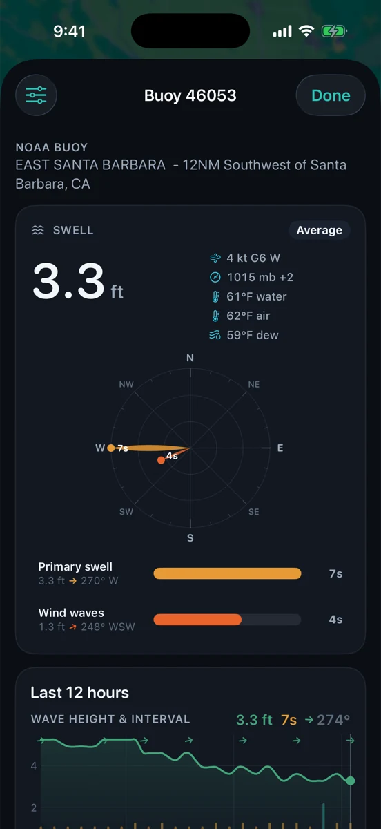
A buoy is different. It reports what one station is measuring at one place. That can be exactly what you need, or it can be a good clue from the wrong side of a point. A buoy outside the Santa Barbara Channel can see swell energy that a protected beach barely feels. A harbor-adjacent station may show wind texture that an offshore buoy misses. Neither source is automatically “right” for your spot. They are answering different questions.
Check the timestamp before the number
Before you compare values, check time. A forecast can be updated on a schedule. A buoy can lag, drop a sensor, or report a burst that has already passed. If a buoy observation is stale, do not treat it like live water. If a forecast discussion was issued before the afternoon wind filled in, read it with that age in mind.
This is especially important around fast-changing local wind. Ten minutes of gusts at the wrong harbor mouth can matter more than the day’s broad sea-height line. On the other hand, a single high gust on a buoy does not prove the whole zone is blown out. Look for trend, not drama.
Read period and direction, not just height
Wave height gets the dock-talk attention because it is easy to picture. Period and direction explain a lot of the mismatch. Three feet at eight seconds can feel like short local chop. Three feet at sixteen seconds can carry more energy and bend into places the number alone does not warn you about.
Direction decides who is exposed. A west swell, south swell, and steep wind sea can show similar heights and feel completely different depending on the coastline in front of you. If the buoy is showing energy from an angle your spot does not receive well, the mismatch makes sense. If the angle lines up with your beach, entrance, or fishing zone, pay attention.

Add tide stage to the argument
Tide predictions do not tell you the weather. They tell you the expected astronomical water level at a station. But tide stage changes how wind and swell show up locally. Wind against tide can steepen chop. A shallow entrance can care a lot about a falling tide. A beach can lose its useful sandbar window before the buoy looks different.
That means the forecast and buoy can both be reasonable while your spot still changes fast. For boaters and sailors, the tide may turn a manageable ride into a sloppy one near the entrance. For anglers, the same wind and swell can fish differently on the flood than on the ebb. For surfers, the water level can decide whether the swell has a clean corner or too much water under it.
A simple disagreement checklist
When the sources do not line up, try this boring sequence. First, check age: when was each source updated? Second, check scale: is the forecast regional while the buoy is outside, inside, or beside your target water? Third, check period and direction: is the energy aimed at you or passing by? Fourth, check tide stage: is water moving with or against the wind where you are going? Fifth, check local shape: harbor mouth, point, island shadow, kelp, shoal, or beach slope.
If the mismatch still looks unresolved, do not average it into a fake green light. Treat uncertainty as a useful answer. The point of a pre-check is not to win an argument with the ocean. It is to notice when the easy story is too easy.
How RipCat helps without pretending to decide
RipCat puts NWS marine forecasts, NOAA tide predictions, and NOAA/NDBC and compatible CDIP buoy observations near each other for U.S. waters. The app is not trying to replace charts, official notices, seamanship, local knowledge, or eyes on the water. It is trying to make the honest pre-check faster: forecast, buoy, tide, advisory timing, then your judgment.
If you want to read by use case, start with the boating and sailing view, the fishing view, or the surf view. Station-specific tide pages are still in pilot review, so this guide links to the best available segment pages for now.
Read the mismatch before you go.
RipCat keeps marine forecasts, tide predictions, buoy observations, and advisory timing in one clean app. U.S. coverage only. Forecasts, observations, and predictions are planning aids, not navigation advice.
Get RipCat free on the App Store