Sea height is one of the first numbers people scan before a run, a sail, a beach day, or a surf check. It is also one of the easiest numbers to misread. A forecast that says “seas 3 to 4 feet” can sound tidy. A buoy showing a 4-foot significant wave height can sound like a hard limit. Neither sentence means every wave will be that size.
The useful habit is simple: treat significant wave height as a starting clue, then read period, direction, wind, tide stage, and local shape around it. The number matters. The context decides what it feels like.
What “significant” means
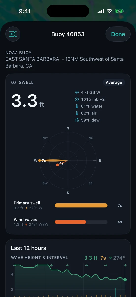
Significant wave height is a statistical summary of the wave field. In plain English, it is close to the average height of the highest one-third of waves during the observing window. That makes it much more useful than a random single wave, but it does not mean bigger waves are impossible.
Some waves will be smaller. Some will be larger. A small set of larger waves can arrive in groups, especially when long-period swell mixes with local wind sea. That is why experienced mariners do not turn a single height number into a green light. They ask what kind of water is making that height.
Forecast seas and buoy readings are not the same thing
A National Weather Service marine forecast describes a zone. It may include wind waves, swell, combined seas, advisory timing, and a text explanation of the expected setup. A buoy is a point observation from one place in the water. Both are useful, but they answer different questions.
If the Santa Barbara Channel forecast says seas are building, the tide curve still tells you only the predicted water level at the nearest reporting station, not the chop at every harbor entrance. If a buoy outside the Channel shows longer-period energy, a protected corner may see less of it than an exposed beach. If an afternoon tide window lines up with wind, a moderate sea-height number can still feel busy near the entrance. That is the same read-around-it habit in our guides to marine forecast zones and wind against tide.
Period changes the feel
Four feet at seven seconds and four feet at sixteen seconds are not the same animal. Shorter-period waves can feel tight and stacked, especially with local wind on them. Longer-period swell can carry more energy, bend around points, and show up with more push than the height alone suggests.
This is where surfers, boaters, and anglers ask different questions from the same number. A surfer wants to know whether the period and direction reach the beach. A boater wants to know how the energy will sit against wind and current. An angler may care whether the water is organized enough to fish or too stirred up to hold bait where expected.
Direction decides who is exposed
Wave height without direction is half a sentence. A west swell, south swell, and steep northwest wind sea can all be called “four feet” and still behave differently along the same coast. Islands, points, shoals, harbor jetties, and beach angle decide how much of that energy reaches your spot.
For Southern California checks, compare exposed and sheltered water. The same tide window may matter differently inside a bay than along an open beach. A Channel Islands shadow can soften one line of swell while another direction slips through. If you want the next layer down, read wave period, explained: the height number does not know your local corner. You do.

Add wind and tide before making meaning
Wind can turn a manageable swell into sloppy water. Tide can change how that water stacks up at a harbor mouth, sandbar, shoal, or shallow beach. Wind against tide is the classic example: the height number may not look dramatic, but the water can get steeper and less forgiving where current and wind oppose each other.
That does not mean every falling or rising tide is good or bad. It means tide stage belongs in the same read as wind and waves. Check the slope of the tide curve, the timing of the wind shift, and whether the place you care about squeezes water through a narrow entrance or spreads it across an open beach.
A practical read
Start boring. Check the timestamp. Is the buoy fresh? Is the forecast newer than the last wind change? Then read height, period, direction, wind, gusts, and tide stage together. Ask whether the station is exposed to the same water as your target. Ask whether the local shape amplifies or hides that energy.
If the forecast, buoy, and tide all point the same direction, you have a cleaner picture. If they disagree, do not average them into a fake answer. Treat the disagreement as information. The ocean is allowed to be messy; your pre-check should leave room for that.
How RipCat helps without pretending to decide
RipCat puts NOAA/NDBC and compatible CDIP buoy observations, National Weather Service marine forecasts, and NOAA tide predictions near each other for U.S. waters. It is built to make the honest pre-check faster, not to replace official notices, charts, local knowledge, seamanship, beach judgment, or eyes on the water.
Read more by use case in the boating and sailing view, the surf view, or the fishing view. Use the station pages as a tide baseline, then read around them with the forecast, the buoy, and the water in front of you.
Read the whole water story.
RipCat keeps marine forecasts, tide predictions, buoy observations, and advisory timing in one clean app. U.S. coverage only. Forecasts, observations, and predictions are planning aids, not navigation advice.
Get RipCat free on the App Store